Thursday, August 8, 2013

Severe Thunderstorm Watches with no storms??? What gives???

On Wednesday August 7th, 2013... ingredients were right for severe thunderstorms to develop across Southern Ontario with an approaching pre frontal trough and a trailing cold front being the triggers for storm development.

The airmass was quite warm and humid and there was enough convective energy and windshear (winds turning with height) to sustain thunderstorms across the region.
Subsequently, Environment Canada issued a Severe Thunderstorm Watch for a large portion  of Southern Ontario in the morning and extended it to other areas early in the afternoon.

A Severe Thunderstorm Watch means that conditions are favourable for the development of severe weather. It's not a guarantee that you will see severe weather, but that you should have a heads up that the possibility exists.

A Severe Thunderstorm is one that has any one of the following....
  • Wind gusts of 90km/h+
  • Rainfall expected of 50mm+ in one hour or less OR 75mm+ in 3hours
  • Hail of 2cm or greater diameter
Lightning is NOT a parameter for severe thunderstorms as all thunderstorms have lightning, otherwise they would just be rainshowers. However, should intense lightning be expected, it will be mentioned in the watch/warning statement.

Even if it's currently sunny and beautiful over your region... a severe thunderstorm watch can still be issued, which was the case for many in Southern Ontario on Wednesday. As I mentioned above, a cold front was the trigger... so the longer the sunny periods last over your region before the trigger moves in, the more heating of the ground and more unstable the atmosphere becomes.

Severe thunderstorm watches can be issued hours in advance if conditions are ripe for the development of such storms.... but again, it's NOT a guarantee that severe weather will occur.
When a WARNING is issued.... that means that severe weather is imminent or occurring.

Now that all the ingredients are in place for thunderstorms... we have to wait for them to fire up. Where they fire up becomes more of an educated guess. Certain atmospheric parameters exist in particular areas that will be conducive to rapid development as compare to others. Locations that are closer to the Lakes often have what's called convective inhibition (CIN),  as modified air from the lakes in the lower levels alters the convective process as compared to locations just a bit further inland.

Storms were expected to be scattered across the region rather than linear (lined up along the front). Therefore it was necessary to have the watch cover a larger region rather than a focussed area.
Below is a snapshot of the watches (Yellow) and warnings (Red) that were issued yesterday afternoon/evening. The red areas had many tornado warnings issued within them.


On Wednesday... a particular area northwest of the Golden Horseshoe seemed to be a bullseye for strong storms and possible tornadic activity. In the graphic below from the Storm Predicition Centre in the USA, the area in red had a higher probability of a tornado forming somewhere in that area. But you can also see that the area of higher probability of severe weather extended quite a bit around it, encompassing the Golden Horseshoe region and much of Southern Ontario.
Tornado warnings were issued in that  red area and a probable tornado did occur with many witness photos being taken. Environment Canada is on the scene today investigating the damage.


Severe thunderstorms continued to pop up all across Southern Ontario into the evening hours and late night. Some areas saw them, some did not. But the Watch was issued for the entire region due to the sporadic nature of the storms. One such cluster of storms moved just to the south of Hamilton in the early morning hours around midnight to 1am. It missed Hamilton by about 20km.

So remember... the next time a Severe Thunderstorm Watch is issued for your region, it gives you the heads up of the possibility of severe weather. Don't ignore it... keep it in the back of your head that you may need to put into action a safety plan should the weather start to become severe. After all... it's better to be safe than sorry.


Thursday, August 1, 2013

Cool will likely rule for August 2013.

Cooler than normal temperatures have ended July and will continue into August thanks to an upper level trough over the Great Lakes region. This trough effectively blocks hot and humid air from making it's way northwards.
Several computer models are supporting this cooler trend to continue well into August and perhaps into September.
The CFS or Climate Forecast System is a model that targets specific months given the past state and forecasted state of the atmosphere as well as a multitude of other parameters used in the models calculations.
The graphic below is centred on August and shows the temperature departures from the climatological normal across North America. This map has taken the past 14 days model runs, 4 times daily and averaged them to get the output you see below.


The extended version of this model which goes out 45 days has the same area of below normal temps through to September 15th...


The Canadian model temperature departure shows a huge area of below normal temperatures over the next 10 days....

Temperature departures over 2 are considered significant.... this is showing nearly -5 degrees departure over Southern Ontario.

Here is another look at the Canadian GEM (Global Environmental Multiscale) model which shows the a 7 day average from August 4th through 11th (This model only goes out 10 days).


The GFS (Global Forecast System) which is the main American model is showing that below normal area over the region through to August 17th. (This model goes out 16 days)


I should mention that Im not a big fan of the CFS Model (Graphic at the top of this blog)... however several other models are supporting this cool trend over the area and the CFS has continually shown cooler than normal temperatures on each run over the past few weeks. This tells me the model is showing more confidence in it's output.

With that being said, and several other models showing the same trend, you can bet we will be in for a stretch of below seasonal temperatures for the next while. There will be some warmer days... but on average it looks like we are in for a cooler than normal August. Normal high temperatures around the region are about 27 degrees right now, but will slowly begin to drop through the month to near 24 by the end of August.

Sunday, July 21, 2013

STORM SUMMARY - JULY 19th 2013

AWCN11 CWTO 212152
UPDATED WEATHER SUMMARY FOR ALL OF SOUTHERN ONTARIO AND THE
NATIONAL CAPITAL REGION ISSUED BY ENVIRONMENT CANADA
AT 5:40 PM EDT SUNDAY 21 JULY 2013.

-------------------------------------------------------------
==WEATHER EVENT DISCUSSION==


A HOT AND HUMID AIR MASS AHEAD OF A COLD FRONT PROVIDED THE PERFECT
COMBINATION TO SET OFF SEVERE THUNDERSTORM ACTIVITY ACROSS CENTRAL
AND SOUTHERN ONTARIO FRIDAY. THE SEVERE WEATHER BECAME EXTENSIVE
DURING THE AFTERNOON AND EVENING HOURS RESULTING IN THE BIGGEST
SEVERE WEATHER OUTBREAK OF THE SEASON.  AN EXCEPTIONALLY LARGE AREA
WAS AFFECTED, FROM WINDSOR TO OTTAWA AND FROM LAKE ERIE TO NORTH BAY.

FRIDAY MORNING, THUNDERSTORMS GAVE SEVERE WIND DAMAGE TO CALLANDER
(NEAR NORTH BAY) RESULTING IN THE DECLARATION OF A STATE OF
EMERGENCY FOR THE TOWN.

SEVERE THUNDERSTORMS CONTINUED TO DEVELOP EASTWARD AND SOUTHWARD. IN
THE EARLY AFTERNOON, STORMS PRODUCED A SWATH OF DAMAGE FROM
PEMBROOKE TO PETAWAWA WHERE CARS WERE FLIPPED OVER, ROOFS BLOWN
DOWN, TREES UPROOTED, STREET LIGHTS SNAPPED, AND TRAILERS
OVERTURNED.  BY LATE AFTERNOON, WIND DAMAGE WAS REPORTED IN DOZENS
OF COMMUNITIES IN A BROAD SWATH FROM LAKE HURON AND GEORGIAN BAY
THROUGH TO EASTERN ONTARIO.

THE SEVERE STORMS DEVELOPED SOUTHWARD DURING THE EVENING HOURS,
CAUSING WIND DAMAGE IN THE GOLDEN HORSESHOE AND IN SOUTHWESTERN
ONTARIO.  FLOODING AND DOWNED TREES WERE REPORTED IN NIAGARA
FALLS WITH RAINFALL ESTIMATED AT 75 TO 100 MM.  150 MM WAS REPORTED
TO HAVE FALLEN AT RONDEAU BAY.

2 MINOR INJURIES WERE REPORTED IN CHATHAM LATE FRIDAY EVENING WHEN A
TREE FELL ON A CAR WITH THE PEOPLE IN IT.

HUNDREDS OF THOUSANDS OF RESIDENTS WERE LEFT WITHOUT POWER FOLLOWING
THE STORMS. AS OF SUNDAY MORNING, APPROXIMATELY 50,000 HOMES
REMAINED WITHOUT POWER.

ENVIRONMENT CANADA STORM DAMAGE TEAMS HAVE INVESTIGATED DAMAGE IN
BARRIE, ORILLIA, GRAVENHURST, HAMILTON, PETAWAWA, CALLANDER AND
DUFFERIN COUNTY. THE MOST SEVERE DAMAGE WAS FOUND NEAR
HONEYWOOD, IN DUFFERN COUNTY, WHERE ESTIMATED WINDS OF 150 KM/HR
DESTROYED A CATTLE BARN AND THREW THE ROOF 300 METRES.  THIS DAMAGE
RATES F1 ON THE FUJITA SCALE.  EVIDENCE THUS FAR INDICATES THAT
THE STORM DAMAGE IN ONTARIO HAS BEEN DONE BY STRAIGHT LINE DOWNBURST
WINDS.

BELOW IS A LIST OF THE MOST SIGNIFICANT DAMAGE REPORTS THAT
ENVIRONMENT CANADA HAS RECEIVED AS OF 4:00 PM SUNDAY.

-------------------------------------------------------------
TIME(LCL)       LOCATION        EVENT DESCRIPTION

10:50 AM        CALANDER        TREES DOWN AND UPROOTED, HOMES
                                DAMAGED, POWER OUTAGES

11:20 AM        GRAVENHURST     2.5 CM HAIL

12:40 PM        PETAWAWA AND    ROOF DAMAGE, TRAILERS FLIPPED,
                PEMBROOKE       POWER OUTAGES

12:55 PM        PETAWAWA PLAZA  FRONT FACET OFF, WINDOWS BLOWN OUT,
                                ROOF CAVED IN

1:55 PM         GRAVENHURST     LARGE TREES DOWN, POWER LINES DOWN

2:30 PM         COLDWATER       TREES DOWN AND SNAPPED, POWER OUTAGES

2:45 PM         GRAVENHURST     CARS OVERTURNED

2:50 PM         ORILLIA         TREES DOWN, POWER LINES DOWN, STREET
                                LIGHTS SNAPPED

2:55 PM         LAKE DALRYMPLE  POWER LINES AND TREES DOWN

3:00 PM         W OF OTTAWA     ROOF DAMAGE, CROP DAMAGE, TREES DOWN

3:00 PM         S OF GULL LAKE  150 TREES DOWN ON SOUTH MORRIS ISLAND

3:15 PM         BARRIE          FUNNEL CLOUD, TREES DOWN - CAUSED
                                DAMAGE TO HOMES

3:20 PM         SE OF           TREE DAMAGE
                BRACEBRIDGE

3:20 PM         BOBCAYGEON      TREES UPROOTED

3:30 PM         KANATA          LARGE HAIL

4:00 PM         N OF ARTHUR     TREES DOWN

4:35 PM         BARRIE          BUILDING DAMAGE, TREES SNAPPED,
                                POWER OUTAGES

5:10 PM         OTTAWA          BRANCHES DOWN

5:10 PM         BORDEN          WIND GUST OF 96 KM/H

5:10 PM         MULMAR          BARN ROOF THROWN 300 METRES, BARN
                                DESTOYED NEAR HONEYWOOD, F1 DAMAGE,
                                WINDS ESTIMATED AT 150 KM/HR, F1
                                DAMAGE

5:15 PM         NAPANEE         TREES DOWN, GAS LEAKS, POWER OUTAGES

5:30 PM         INNISFIL        FUNNEL CLOUD, LIMBS DOWN

5:30 PM         WATERLOO ARPT   WIND GUST OF 119 KM/H, TREES DOWN

5:35 PM         SW OF BRADFORD  FUNNEL CLOUD

5:40 PM         GUELPH          DOZENS OF TREES SNAPPED OR UPROOTED,
                                HUNDREDS OF BRANCHES DOWN, DAMAGE TO
                                HOMES FROM FALLEN TREES OR LIMBS

5:45 PM         CASSELMAN       53 MM RAIN

5:50 PM         KITCHENER       TREES DOWN - CAUSED DAMAGE TO HOMES,
                  -WATERLOO     POWER OUTAGES, DAMAGE TO BUS SHELTER

5:50 PM         STRATFORD       TREES DOWN

5:55 PM         PORT CARLING    MATURE TREES DOWN, TREES SNAPPED
                PORT SEVERN

5:55 PM         GRAVENHURST     LARGE TREES DOWN, POWER LINES DOWN

6:00 PM         TORONTO PEARSON WIND GUST OF 104 KM/H

6:00 PM         PARIS           TREE DAMAGE, WOODEN BALCONY TORN OFF
                                HOUSE, CINDERBLOCK WAREHOUSE COLLAPSE

6:10 PM         TORONTO         TREES DOWN, INCLUDING A
                                HISTORIC CENTURY OLD TREE, POWER
                                LINES DOWN

6:30 PM         HAMILTON        TREES DOWN

6:45 PM         STONEY CREEK    TREES DOWN, TREES SNAPPED

7:05 PM         HAMILTON ARPT   WIND GUST OF 104 KM/H

7:10 PM         ST CATHARINES   TREES DOWN, 75-85 MM OF RAIN,
                                FLOODING

7:3O PM         CHATHAM         TREES DOWN, POWER LINES DOWN,

7:45 PM         GRIMSBY         TREES DOWN, POWER OUTAGES, 65 MM OF
                                RAIN

7:45 PM         WATERDOWN       TREES DOWN

8:20 PM         CHATHAM-KENT    TREES DOWN, POWER OUTAGES

8:30 PM         ANCASTER        TREES AND POWER LINES DOWN, SMALL
                                HAIL

8:45 PM         NORWICH         WIND GUST OF 90 KM/H, TREES DOWN

9:00 PM         MULMUR          BARN DAMAGE, CROP DAMAGE, ROOF
                                DAMAGE, POWER OUTAGES

9:10 PM         HAMILTON ARPT   WIND GUST OF 106 KM/H

9:20 PM         MOUNT HOPE      TREES DOWN, TRAMPOLINE BLOWN ONTO
                                ROOF, CROP DAMAGE

10:00 PM        PORT COLBORNE   WIND GUST OF 98 KM/H

11:00 PM        PORT COLBORNE   WIND GUST OF 93 KM/H, POWER OUTAGES

02:00 AM (SAT)  WATERLOO ARPT   WIND GUST OF 91 KM/H


REPORTS WITH EXACT TIME UNKNOWN:

                ST GEORGE       TREES AND HYDRO LINES DOWN
                ESSEX COUNTY    TREES DOWN
                SIMCOE COUNTY   TREES DOWN
                RONDEAU BAY     150 MM RAIN
                CHATHAM         MINOR INJURIES TO TWO PASSENGERS OF
                                A CAR
                WIARTON         LARGE TREE UPROOTED
                BLENHEIM        TREES DOWN, FLOODED BASEMENTS, POWER
                                OUTAGES
                NIAGARA FALLS   75-100 MM RAIN, FLASH FLOODING
                BEAMSVILLE/     75-85 MM RAIN, FLASH FLOODING
                    VINELAND

Monday, June 17, 2013

Weather Event Discussion from EC - June 16th 2013

Updated weather summary for all of Southern Ontario and the
National Capital Region issued by Environment Canada
At 7:25 AM EDT Monday 17 June 2013.

-------------------------------------------------------------
==weather event discussion==

Several areas of thunderstorms roared across Southern and Eastern
Ontario, spawning numerous reports from Canwarn trained and
Ontario provincial police spotters of pea to marble sized hail,
frequent lightning, very heavy downpours and strong and gusty winds.
The strongest thunderstorms of the series from father's day roared
southeast from Lake Huron across the London area into St Thomas,
dumping hail as large as ping pong balls near Kettle Point and
resulting in tornado warnings for those regions. A funnel cloud was
seen by a Canwarn trained spotter just east of St. Thomas last
evening.

Severe weather reports received by Environment Canada as of 6.30
AM are found in the table below.

All watches and warnings have been ended by Environment Canada.

-------------------------------------------------------------
Time(lcl)           location        event description

7.00 PM            2 km E Kettle Point  4 cm hail 9.00 PM (EST'd)  
E of St Thomas       funnel cloud 9.20 PM            Stayner area   
    pine trees down
10.10 PM            Mount Albert         2 cm hail
11.05 PM            Bowmanville          2 cm hail

Friday, May 24, 2013

3rd and 4th Tornadoes confirmed in Ontario from May 21st 2013

AWCN11 CWTO 242021
Weather summary for all of Southern Ontario and the
National Capital Region issued by Environment Canada
At 4:16 PM EDT Friday 24 May 2013.

-------------------------------------------------------------
==weather event discussion==

Third and fourth tornadoes of the season confirmed.

Ongoing investigations by Environment Canada personnel in the wake of
the strong thunderstorms on May 21 have led to the confirmation of
two additional tornadoes on this day.

At approximately 1:30 PM EDT on Tuesday May 21, an enhanced Fujita
scale zero (ef-0) occurred near the community of Elmvale which is
about 18 kilometres south of Midland. The peak winds involved in this
event were between 90 and 130 kilometers per hour. The length of
damage was 570 metres and the maximum width was 50 metres. The
tornado uprooted or snapped about a dozen mature trees and did very
minor damage to a barn roof.

At approximately 2:00 PM EDT on Tuesday May 21, another enhanced
Fujita scale zero (ef-0) tornado occurred near the community of
dalston which is about 12 kilometres north of Barrie. The length of
damage was 4.5 kilometres and the maximum width was 500 metres. At
least 50 mature trees were uprooted or snapped off along the track
and the cap of a farm silo was damaged.

The enhanced Fujita scale is used to rate the intensity of tornadoes
and damaging wind events. The scale goes from zero (weakest) to 5
(strongest).

Ontario has had 4 tornadoes so far this year. Ontario normally has 12
tornadoes each year in a season that runs from late April until early
October.

CHILLY START TO THE DAY....

What a chilly morning... temperatures only around 4°C with gusty winds making it feel like zero.
Reports of flurries north and west of the city around Kitchener and Elora this morning.

Wednesday, May 22, 2013

EF-2 Tornado Confirmed in Glenarm, Ontario ... May 21st 2013

AWCN11 CWTO 230915
Updated weather summary for all of Southern Ontario and the
National Capital Region issued by Environment Canada
At 5:15 AM EDT Thursday 23 May 2013.

-------------------------------------------------------------
==weather event discussion==

Second tornado of the season confirmed in Ontario

An Environment Canada damage survey team has confirmed the
Occurrence of the second tornado of the season in Ontario. At
approximately 3 PM EDT Tuesday, near the small community of glenarm
about 12 kilometres to the west of Fenelon Falls, an enhanced Fujita
scale 2 (ef-2) tornado occurred. The main damage that verified this
rating was the roof being removed from a house in that area. This
damage is consistent with the low end of the ef-2 category or wind
speeds between 180 and 200 kilometres per hour. The enhanced Fujita
scale goes from ef-0 (weakest) to ef-5 (strongest).  This tornado
Had a path length of 7 km and a width of 500 metres.  There is also
sporadic damage along this path in the form of downed trees and one
destroyed older barn.

This is the second tornado of the season in Ontario. Ontario normally
has 12 tornadoes each year in a season that runs from late April
until early October.

In addition, a second damage path that was 10 km long was identified
to the southwest of Fenelon Falls.  This damage appeared to be
Caused by straight line winds.  There was also sporadic downed trees
and a destroyed older barn along this path, in addition to several
damaged cars at a car delearship from flying Debris.

Weather Event Summary - May 21st 2013

AWCN11 CWTO 221029
Updated weather summary for all of Southern Ontario and the
National Capital Region issued by Environment Canada
At 6:21 AM EDT Wednesday 22 May 2013.

-------------------------------------------------------------
==weather event discussion==

Two clusters of thunderstorms blasted across Southern Ontario
Tuesday afternoon as the warm air of summer continues to battle a
much cooler airmass just to the north. There were quite a few
Reports of small hail, very heavy downpours, strong and gusty winds
and frequent lightning from the thunderstorms, which were also
responsible for a number of power outages.

There was damage to trees and buildings reported at cambray, which
Is southwest of Fenelon Falls, as the first area of thunderstorms
roared across. A team from Environment Canada will travel to the
Fenelon Falls area today to assess the damage.

These thunderstorms spawned a number of severe thunderstorm watches
and warnings which have since been discontinued.

Reports from severe thunderstorms received by Environment Canada as
of 6.00 AM today are found in the table below.

-------------------------------------------------------------
Time(lcl)       location                   event description

1.50 PM         Orangeville                2 cm diameter hail

3.00 PM         stouffville                2-3 cm hail

3.30 PM         cambray (sw Fenelon Falls) barn down
                                           Trees down
                                           Roof torn from a house
                                           Power lines down

4.50 PM         laurel (nw Orangeville)    2.5 cm hail

Friday, May 17, 2013

Thunderstorm Potential Next Week.....

Possibility of thunderstorms next week perhaps Monday and Tuesday. Two convective weather indexes are showing the potential for some good thunderstorm activity. The lifted Index and Convective Available Potential Energy. Below is a brief ex...planation of the two indexes mentioned. There are other things to look at as well, but for now I will just talk about the following.

Lifted Index is the difference in temperature of a parcel of air that is lifted to particular height compared to it's surrounding environment. Positive values indicate stable atmospheric conditions. Negative values indicate instability. The greater the negative value, the more unstable the atmosphere is.

Convective Available Potential Energy or CAPE is the amount of energy a parcel of air would have if lifted to a certain height in the atmosphere. The higher the number the more energy that parcel of air has to lift. Values over 2500 are generally associated with severe weather.

There is also Convective Inhibition or CIN. This is basically the opposite of CAPE and inhibits convection from taking place or slows it down due to a temperature inversion near the surface. When CIN values are very negative (at least -100 or greater) air cannot rise past the inversion layer or the CAP. If CIN values are small (about -25 or so), convection may have enough energy to push through the inversion layer and thunderstorms will develop.


Monday, May 13, 2013

Across Canada on Sunday May 12th 2013


FROST WARNING - May 13th 2013

SEVERE WEATHER BULLETIN
ISSUED BY ENVIRONMENT CANADA
AT 3:20 PM EDT MONDAY 13 MAY 2013.
---------------------------------------------------------------------
WATCHES/WARNINGS IN EFFECT FOR SOUTHERN ONTARIO...

FROST WARNING FOR:
      CITY OF TORONTO
      ELGIN
      LONDON - MIDDLESEX
      SIMCOE - DELHI - NORFOLK
      DUNNVILLE - CALEDONIA - HALDIMAND
      OXFORD - BRANT
      NIAGARA
      CITY OF HAMILTON
      HALTON - PEEL
      YORK - DURHAM
      HURON - PERTH
      WATERLOO - WELLINGTON
      DUFFERIN - INNISFIL
      GREY - BRUCE
      BARRIE - ORILLIA - MIDLAND
      BELLEVILLE - QUINTE - NORTHUMBERLAND
      NAPANEE - CONSECON
      KINGSTON - ODESSA - FRONTENAC ISLANDS
      PETERBOROUGH - KAWARTHA LAKES
      STIRLING - TWEED - SOUTH FRONTENAC
      BANCROFT - BON ECHO PARK
      BROCKVILLE - LEEDS AND GRENVILLE
      CITY OF OTTAWA
      GATINEAU
      PRESCOTT AND RUSSELL
      CORNWALL - MORRISBURG
      SMITHS FALLS - LANARK - SHARBOT LAKE
      PARRY SOUND - MUSKOKA
      HALIBURTON
      RENFREW - PEMBROKE - BARRY'S BAY
      ALGONQUIN
      BURK'S FALLS - BAYFIELD INLET.

      WIDESPREAD FROST TONIGHT.

---------------------------------------------------------------------
==DISCUSSION==
CONDITIONS WILL BE MORE FAVOURABLE FOR FROST TONIGHT AS SKIES CLEAR
AND WINDS BECOME LIGHT IN A CHILLY ARCTIC AIR MASS. TEMPERATURES
WILL FALL TO ZERO SO WIDESPREAD FROST IS EXPECTED OVERNIGHT AND
EARLY TUESDAY MORNING.

TENDER PLANTS SHOULD BE PROTECTED OR BROUGHT INDOORS OUT OF THE COLD
THIS EVENING IF POSSIBLE.

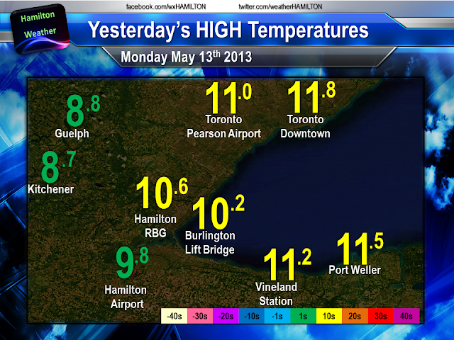
Chilly Morning For The Golden Horseshoe


Certainly not the your typical temperatures for the middle of May. Cold air across the region will only get temps up to the upper single digits for this afternoon. Some instability across the region will also spark off some showers and possible ice pellets/snow pellets this afternoon due to cold air aloft.